nothardanger
8 photos tagged nothardanger, from 1 member of Flickr Commons.
When were these photos taken?
Where were these photos tagged?
None of these photos are geotagged.
Related tags
Tags that often appear on the same photos:
- color
- colorized
- libraryofcongress
- hordaland
- photochrom
- xmlns:dc=httppurlorgdcelements11
- detroitpublishingcompany
- norway
- nærøydalen
- road
- voss
- vosskommune
- sogn
- stalheimskleiva
- thenandnow
- thennow
- commonsthennow
- lake
- fence
- landscape
- iggh
- mountains
- stalheim
- fjord
Members using this tag
Photos
Photos tagged nothardanger:
Loading photos…
Recent uploads
The last upload was January 2009.

Framnaes Hotel & lake [Norway] (LOC) from The Library of Congress uploaded January 2009

[Vinge Hotel, Hardanger Fjord, Norway] (LOC) from The Library of Congress uploaded January 2009

Norwegian carriage [Norway] (LOC) from The Library of Congress uploaded January 2009

Stalheimskleven [Norway] (LOC) from The Library of Congress uploaded January 2009

Naerodalen (ie. , Nærøydalen) [Norway] (LOC) from The Library of Congress uploaded January 2009

[Naerodalen, Hardanger Fjord, Norway] (LOC) from The Library of Congress uploaded January 2009

On the Voss Railway [Hordaland, Norway] (LOC) from The Library of Congress uploaded January 2009

Vossevangen, general view [Lake Vangsvatnet, Norway] (LOC) from The Library of Congress uploaded January 2009
Conversations
Here’s a selection of the conversations happening on these photos:
Vossevangen, general view [Lake Vangsvatnet, Norway] (LOC)
- 1 older comment, and then…
- Aware Thing said:
- Kjetil Birkeland Moe said:
- jonhl said:
- bergenser said:
- Pixel Wrangler said:
Framnaes Hotel & lake [Norway] (LOC)
-
jonhl said:
Norwegian modern spelling "Oppheimsvannet" or "Oppheimsvatnet". On Google Maps spelt "Uppeimsvatnet". This is a lake in the mountains on the way from Voss over to Sogn, and it's not really close to the Hardangerfjord.
-
Arild Finne Nybø said:
Belongs to Voss kommune (municipality), and is as vyxir says closer to Sognefjorden (The Sognefjord) and its arm Nærøyfjorden (The Naeroey fjord).
-
The Library of Congress said:
vyxir and arnybo, thank you for this information! We will correct the source data and reload the description.
[Naerodalen, Hardanger Fjord, Norway] (LOC)
- 1 older comment, and then…
-
basskornett said:
The road winding upwards must be Stalheimskleiva, once famous for being a rather hazardous drive.
-
Øyvind Heen said:
This is not a part of Hardangerfjord. The road between Voss and Stalheim continues down the Naeroydalen valley and ends in Gudvangen. This is where Naeroyfjord starts (UNESCO World Heritage). Naeroyfjord is a branch of the longest fjord in Norway, Sognefjord (204 km long). Check out www.naeroyfjord.com
-
The Library of Congress said:
Thanks! We'll fix the title in the source data and reload description.
-
Pixel Wrangler said:
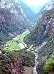
Nærøydalen – Then and Now (100+ years later)
"Stalheim (2007)" by finnabotn "Nærøydalen (c.1900)" by Detroit Pub.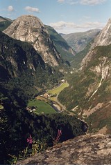
![[Naerodalen, Hardanger Fjord, Norway] (LOC)](http://static.flickr.com/3081/3174186173_5ca125807a_m.jpg)
-
Roger W said:
The view from Stalheim in July 1993.