Conversations
Here are conversations that have happened in the last week on Flickr Commons:

New Year revels & concert at Ingleburn Military Camp, Sydney, 1941

- 3 older comments, and then…
-
nacho pippen said:
Wonderful picture
-
Flickr said:
Congrats on Explore! ⭐ February 26, 2026
-
Michael Gschwind said:
Glückwunsch zu Explore !
-
Cornelis M.J. said:
Congratulations on your photo in Explore !
-
Francesco Dini said:
Congrats on making Explore! 🎉✨ 👏 - Amazing capture! ✨
-
Lukas Larsed said:
Congrats on Explore 🏆
-
Sigurd Krieger said:
Congrats on Xplore!!
-
gato-gato-gato said:
Nett!
-
Ann Seedhouse said:
Admired your photography, congratulations on explore 👌🏆🌟 such fun
A beauty built for speed!

- 1 older comment, and then…
-
beachcomber australia said:
The 'Ulster' (2) dates from 1896 ... en.wikipedia.org/wiki/City_of_Dublin_Steam_Packet_Company
-
beachcomber australia said:
The signal flag on the foremast via megazoom ...

"The blue Peter.
In harbour: All persons should report on board as the vessel is about to proceed to sea.
At sea: It may be used by fishing vessels to mean: "My nets have come fast upon an obstruction."
via - en.wikipedia.org/wiki/International_maritime_signal_flags -
National Library of Ireland on The Commons said:
beachcomber australia Thank you. 30 years lopped off our date range.
-
Suck Diesel said:
The RMS Connaught in this photo looks remarkably similar
www.reddit.com/r/Oceanlinerporn/comments/sq7yrf/a_picture... -
beachcomber australia said:
We met the 'Ulster' (2) before; lots of date stuff. Not sure it is the same day -

-
beachcomber australia said:
{Aside] The previous 'Ulster' (1) was a beauty also (4 funnels until 1886) - catalogue.nli.ie/Record/vtls000337385
2 funnels after 1886 - catalogue.nli.ie/Record/vtls000337384 -
National Library of Ireland on The Commons said:
beachcomber australia At least not a Déjà Vu! Those give us The Horrors. And The Heebie-Jeebies.
-
Mike Grimes said:
Suck Diesel Someone has been at Photoshop in Reddit methinks.
-
Niall McAuley said:
L_ROY_01690 next door includes a familiar figure, Davy Stephens, previously featured in 1905 in
NLI Ref.: L_ROY_08992 below:
Drawing (allegedly), unidentified building (definitely).

- 32 older comments, and then…
-
derangedlemur said:
Finally found this one - it's the caserne Durutte in Douai - counterpart to this artillery barracks: maps.app.goo.gl/dnoFPgCuXj5W6q1S9
Doesn't seem to still be standing.
Edit: the park in the foreground is Place St Jacques. It's a bus station now. I think it was this side of the park: maps.app.goo.gl/1YHpfn1gbv6jSW4M6
douaivox.fr/douai-en-1900/ -
National Library of Ireland on The Commons said:
As beachcomber australia would say, derangedlemur is ALWAYS amazing!
-
beachcomber australia said:
Well done The Lemur!
Title says "L’austère façade de la Caserne Durutte de la place Saint Jacques" , which Google translates as "The austere facade of the Durutte Barracks on Place Saint Jacques"
From - douaivox.fr/douai-en-1900/ -
beachcomber australia said:
eBay is also sometimes amazing!
www.ebay.co.uk/itm/376664204729 -
Niall McAuley said:
derangedlemur Well done!
26_0015055 Rohr Collection Image

from SDASM Archives
-
Chuck Walla said:
Tall guy on the left may be Don Rice or Bob Rice? I can't read the name tag clearly.
26_0015046 Rohr Collection Image

from SDASM Archives
-
Chuck Walla said:
Newspaper articles from the period suggest this might be used to form titanium parts. Your corrections are welcomed.
Did the Cutting on Sark lead to the Cutty Sark?

- 16 older comments, and then…
-
Niall McAuley said:
I see an article about wind power for Sark from 2024, and it says: The challenging thing is that the only way to get all the necessary supplies on Sark is through one of the two tunnels. So these tunnels define all the dimensions.
-
O Mac said:
Creux Harbour.
maps.app.goo.gl/NQBSUKSPRR55PnPf6 -
Suck Diesel said:
Creux Harbour on the island of Sark
-
National Library of Ireland on The Commons said:
O Mac Suck Diesel You both got to the Creux of the matter!
-
beachcomber australia said:
Flickr is sometimes amazing! In June 2018 via maykal

-
John Spooner said:
In a review of the Portland Gallery, London, the review remarks on a work by a Mr.Naish entitled "Creux Harbour" thus:
Mr. Naish has this year chosen another view in the Island of Sark, namely, " Le Creux Harbour" (463)-just such a tiny sheltered inlet as one might expect to find in so diminutive an island, and just such a grottoed nook as a mermaiden might haunt to wring out her tresses, were it not overhung by a lofty jetty, and profaned by Jersey boatmen.
(Daily News (London) - Monday 21 March 1859 -
beachcomber australia said:
And an oldie before the arch was built, as in today's photo,
via memories of days gone by
Edit: There seems to be a metal bridge in this one ... -
beachcomber australia said:
Closer ! Via stut

-
John Spooner said:
The Guernsey Star - Tuesday 29 August 1876 says that the tunnel is obvious enough to the visitor arriving at Creux harbour, BUT
Not so was it some years back, when the tunnel connecting the harbour with the interior of the island ran at right angles to its present course, and when, says a guide-book, " so singularly concealed was the approach, that the Lords of the Admiralty, arriving at Sark on their tour of inspection, and intending to land, actually did land on the breakwater; but, there being no human being in sight and no one knowing the state of the case, their lordships gave up the task as hopeless, and returned on board in search of less difficult landing-places and better known if less picturesque spots."


26_0068986 Rohr Collection Image

from SDASM Archives
-
Chuck Walla said:
This may have been shot from the Cesar Chavez Parkway overcrossing. Corrections are welcomed.
School Girl Grace Glaeser

-
Friedrich Kahlo and Freyja Strongheart (and archived Fritz Rambo and Pablo Fonzirelli) World's Greatest Dogs (Rob Keim) said:
This says Date unknown, but she doesn't look much older than in this 1936 photo:

-
Cloyne and District Historical Society said:
Fritz Rambo, Pablo Fonzirelli, Friedrich Kahlo World's Greatest Dogs Good catch. There is no date with the photo; however, c1936 would be a good estimate. Thanks for the input!
-
Flickr said:
Congrats on Explore! ⭐ February 24, 2026
-
gloria castro said:
FELICIDADES!!!! muy merecido Explore.
-
Lukas Larsed said:
Congrats on Explore 📷
Portrait: Webb, Beatrice

from LSE Library
-
Roger said:
photo? are you sure?
-
LSE Library said:
Roger a photo of an artwork or an artwork? Can something be two things at once? AJ
-
Roger said:
Oh sure! But I looked at this and thought it looked like the work of a pencil more than the work of a camera. Either way its art .... but maybe they were cleverer with their photos than I think .
Thank you for sharing these images. I am still looking at the recent gifts.
Donagh and Flip

-
beachcomber australia said:
Is young Donagh wearing clip-on antlers?
-
beachcomber australia said:
Donagh MacDonagh (1912- 1968) had an interesting, accomplished, if not entirely happy life -
www.dib.ie/biography/macdonagh-donagh-a5169
en.wikipedia.org/wiki/Donagh_MacDonagh -
Suck Diesel said:
Donagh MacDonagh, son of the Irish poet and revolutionary Thomas MacDonagh, seated on a chair with his dog, Flip.
-
National Library of Ireland on The Commons said:
Always delighted to find named dogs in our collections! Very funny in the albums, where sometimes people aren't named, but dogs (and cats) are named.
-
Foxglove said:
Dog ! Where is Danny m8 sleeping !
-
National Library of Ireland on The Commons said:
Foxglove He'll be ragin'! 😀
-
DannyM8 said:
Foxglove late this morning, nice dog.
A Blissful existence in Newbliss

- 9 older comments, and then…
-
Foxglove said:
Blissful dog too!
-
National Library of Ireland on The Commons said:
Foxglove Blithely blissful.
-
beachcomber australia said:
There are three Royal plates of Main Street, all the same day -
catalogue.nli.ie/Record/vtls000318963 (this photo)
catalogue.nli.ie/Record/vtls000042492 (from further down)
catalogue.nli.ie/Record/vtls000318962 (reverse-ish) -
National Library of Ireland on The Commons said:
beachcomber australia And dogs in all of them!
-
Mike Grimes said:
Streetview 2019.
maps.app.goo.gl/eTccLTqhWUz5cX15A -
National Library of Ireland on The Commons said:
Mike Grimes Good to see the arch survived.
-
John Spooner said:
P. Landy's shop - Patrick Landy of Newbliss was a mourner at the funeral of Owen M'Cartan of Ballydrummond. During his final illness every attention had been paid to him by his good wife and her sister, Miss Landy. (Irish News and Belfast Morning News - Saturday 10 December 1904)
-
Niall McAuley said:
I don't see anthing datable. Fashions are maybe 1905?
-
Niall McAuley said:
There is a sequence of undatable village shots. L_ROY_08350 shows the RC church in Lisnaskea, begun in 1902, dedicated 1907, looking new
Portrait: Webb, Sidney

from LSE Library

And not a Council worker in sight!

- 16 older comments, and then…
-
beachcomber australia said:
Google Lens is sometimes amazing!
Spot the differences!
www.ebay.com/itm/315994685041 -
Suck Diesel said:
Looks like Glacier Garden of Lucerne in Switzerland
-
beachcomber australia said:
The eBay photo from the link above -
ca. 1900
Maennedorf, Lake Zurich, Switzerland
by T, Richard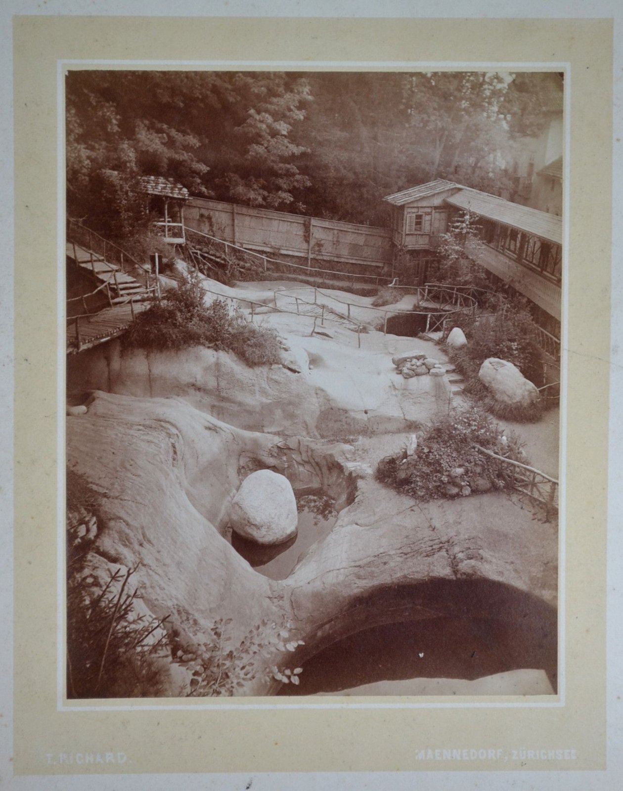
-
beachcomber australia said:
Henry Chichester Hart MRIA FLS (1847–1908) was an Anglo-Irish botanist and explorer.

via - en.wikipedia.org/wiki/Henry_Chichester_Hart
Also - www.dib.ie/biography/hart-henry-chichester-a3831
Conchology !! - www.conchology.be/?t=9001&id=20354&srsltid=AfmBOo... -
National Library of Ireland on The Commons said:
beachcomber australia He was a Conchologist, in addition to everything else?!
-
beachcomber australia said:
National Library of Ireland on The Commons New to me !
en.wikipedia.org/wiki/Conchology
[Aside] There is a dog in Image 31. And a rabbit ... -
beachcomber australia said:
Flickr is sometimes a wider view.
c. 1890 via Internet Archive Book Images
From a book about Lake Dwellers of Switzerland - archive.org/details/ridpathshistoryo01ridp/page/316/mode/1up -
Suck Diesel said:

-
National Library of Ireland on The Commons said:
Suck Diesel That is one hell of a garden umbrella!
Ed Wist and Mower, Hutsie Putsie, Deposit, New York (LOC)

- 2 older comments, and then…
-
Bruce Faling said:
His name is not unknown to me but never met him. At least one his children attended the local school, but he was some grades ahead of me and I can't recall it.
C.E. Magoon, three-quarters bust (LOC)

-
swanq said:
en.wikipedia.org/wiki/Charles_Edward_Magoon
"Charles Edward Magoon (December 5, 1861 – January 14, 1920) was an American lawyer, judge, diplomat, and administrator who is best remembered as a governor of the Panama Canal Zone; he also served as Minister to Panama at the same time. He was Provisional Governor of Cuba during the American occupation of Cuba from 1906 to 1909.
He was the subject of several scandals during his career. As a legal advisor working for the United States Department of War, he drafted recommendations and reports that were used by Congress and the executive branch in governing the United States' new territories following the Spanish–American War. These reports were collected as a published book in 1902, then considered the seminal work on the subject. During his time as a governor, Magoon worked to put these recommendations into practice. In summary: Magoon was hugely successful in Panama but criticized for his tenure in Cuba." -
Jon (LOC P&P) said:
Thanks swanq. we'll update this catalog record.
Harry Putnam, three-quarters bust (LOC)

- 1 older comment, and then…
-
Jon (LOC P&P) said:
Thanks swanq, we'll fix the spelling and add some of this info to the catalog record.
Herbert Putnam, front bust (LOC)

-
swanq said:
en.wikipedia.org/wiki/Herbert_Putnam
"George Herbert Putnam (September 20, 1861 – August 14, 1955) was an American librarian. He was the eighth (and also the longest-serving) Librarian of Congress from 1899 to 1939. He implemented his vision of a universal collection with strengths in many languages, especially from Europe and Latin America." -
Jon (LOC P&P) said:
Thanks swanq. We'll add a little more description to his catalog record.
A.J. Hopkins, front bust, copyright Moffett Studio (LOC)

-
swanq said:
en.wikipedia.org/wiki/Albert_J._Hopkins
"Albert Jarvis Hopkins (August 15, 1846 – August 23, 1922) was a Congressman and U.S. Senator from Illinois." -
Jon (LOC P&P) said:
Thanks swanq, we'll add this information to the catalog record.
Granville Barker, three-quarters bust (LOC)

-
swanq said:
en.wikipedia.org/wiki/Harley_Granville-Barker
"Harley Granville-Barker (25 November 1877 – 31 August 1946) was an English actor, director, playwright, manager, critic, and theorist. After early success as an actor in the plays of George Bernard Shaw, he increasingly turned to directing and was a major figure in British theatre in the Edwardian and inter-war periods. As a writer his plays, which tackled difficult and controversial subject matter, met with a mixed reception during his lifetime but have continued to receive attention." -
Jon (LOC P&P) said:
Thanks swanq, we'll update this catalog record.
Mrs. Waldorf Astor, profile (LOC)

-
swanq said:
I assume this was
www.royal-oak.org/2019/09/26/nancy-astor-and-a-portrait-o...
also
en.wikipedia.org/wiki/Nancy_Astor,_Viscountess_Astor
"Nancy Witcher Astor, Viscountess Astor (19 May 1879 – 2 May 1964) was an American-born British politician who was the first woman seated as a Member of Parliament (MP), serving from 1919 to 1945.[a][1] Astor was born in Danville, Virginia, and raised in Greenwood, Virginia. Her first marriage, to socialite Robert Gould Shaw II, was unhappy and ended in divorce. She then moved to England and married American-born Englishman Waldorf Astor in 1906." -
Jon (LOC P&P) said:
Thanks swanq, we'll add her full name to the catalog record.
Police Commander Bingham, seated, with pipe, New York (LOC)

- 6 older comments, and then…
-
Flickr said:
Congrats on Explore! ⭐ February 21, 2026
-
Michael Gschwind said:
Glückwunsch zu Explore !
-
Lukas Larsed said:
Congrats on Explore 😄
-
Marut Rata said:
💖✨Congrats on EXPLORE ✨
-
Francesco Dini said:
Congrats on making Explore! 🎉✨ 👏 - Love the details ✨
-
Sigurd Krieger said:
Congrats on Xplore!!
-
gato-gato-gato said:
Super Bild, sehr gelungen!
-
Cornelis M.J. said:
Congratulations on this photo in Explore !
⭐
I appreciate if you accept my invitation
and also join this group!
(if you want to see/follow my photostream,
click: www.flickr.com/photos/cmjdumoulin-photo) -
Mr. Happy Face - Peace :) said:
Excellent Work 🌟 Thank You for Sharing
G.B. McClellan, seated three-quarters view (LOC)

-
swanq said:
en.wikipedia.org/wiki/George_B._McClellan_Jr.
"George Brinton McClellan Jr. (November 23, 1865 – November 30, 1940), was an American politician and historian. He was elected as the 94th Mayor of New York City, serving from 1904 to 1909. He was the son of Civil War general George B. McClellan, who was the 1864 Democratic presidential nominee." -
Seuss. said:
George B. McClellan, Jr. Mayor of New York CIty, 1904-1909
Hector_407 Louis Hector Collection Image

from SDASM Archives
-
Jordan Deters said:
This is not a Vultee BT-13. Rather, it appears to be a Republic P-47.
Helen Cannon, profile view, copyright by Clinedinst (LOC)

-
Seuss. said:
Helen A. Cannon (1864-1935) was the daughter of Joseph Gurney Cannon. Joseph Cannon is most famous for lending his name to a building across the street from the Library of Congress. Before that building went up he achieved some fame as a longtime (23 non-consecutive terms between 1873 and 1923) congressman from Illinois and powerful speaker of the house (1903-1911). Though he and T. Roosevelt were both Republicans, while speaker he significantly reigned in the president's rasher and more aggressive policies. Huh. Who knew a speaker could do that?
And because we're photographers and think that photographers matter . . . The "Clinedinst" mentioned in this and other LoC pics refers to Barnett McFee Clinedinst who operated a photo studio in Washington from ~1900 to 1913. He was also the official White House photographer around this time. His father (Barnett Michael Clinedinst) was also a photographer who invented the SLR and Viewfinder -
Seuss. said:
Helen A. Cannon (1864-1935) was the daughter of Congressman Joseph Gurney Cannon of Illinois. Joseph Cannon is most famous for lending his name to the office building across the street from the Library of Congress. Before that building went up he was famous for serving 23 terms in Congress (non-consecutively) from 1873 to 1923 including 8 years as the Speaker of the House (1903-1911). Helen's mother (and Joseph's wife) Mary Reed Cannon (known as Molly) died in 1899, after which Helen served as her father's hostess for the rest of his career in DC.
"Clinedinst" refers to either Barnett Michael Clinedinst or his son Barnett Mcfee Clinedinst, two highly respected DC photographers in the late 19th/early 20th century. Clinedinst fils is the more famous today - operating his studio in DC from ~1899 (the year of his father's death) to 1913 and also being the official White House photographer during much of that time. Although this photo ran in the 1904 Washington Times, based on the apparent age of the sitter I actually think this portrait was the work of Clinedinst pere. A very similar photo of Miss Cannon appears in a 1910 edition of the Washington Herald but she appears to be more than 10 years older than in this portrait.
(note: the elder Clinedinst is of particular interest to modern photographers as he has been credited with the invention of both the optical viewfinder and the SLR.)
The Art of Writing

- 10 older comments, and then…
-
Mike said:
beachcomber australia Good one
Bert Hanson, three-quarters bust, writing (LOC)

-
swanq said:
Could be the Bert Hanson mentioned in
NYT, January 24, 1907, page 16
timesmachine.nytimes.com/timesmachine/1907/01/24/10673724...
Obituary in NYT, Dec. 14, 1938, P. 25
www.nytimes.com/1938/12/14/archives/bert-hanson-dies-civi...
Shanty Club, Routes 79 & 80, Shreveport, Louisiana (LOC)

- 3 older comments, and then…
-
Robert W. said:
It was torn down a few weeks ago.
Hallie Ermine Rives-Wheeler, in Japanese dress (LOC)

-
swanq said:
en.wikipedia.org/wiki/Hallie_Erminie_Rives
"Hallie Erminie Rives (May 2, 1874 – August 16, 1956) was a best-selling popular novelist and wife of the American diplomat Post Wheeler."
From en.wikipedia.org/wiki/Post_Wheeler
"Wheeler married the novelist Hallie Erminie Rives in 1906 in Tokyo. A wedding announcement noted that Wheeler initially considered the Kentucky-born Rives "rather severe on men" in her books and she considered him "none too charitable concerning the faults of women" in his book Reflections of a Bachelor. They met at a reception in New York and began a friendship that eventually led to marriage."
Countess Jametel (Marie of Mecklenburg Strelitz), three-quarters bust (LOC)

-
swanq said:
en.wikipedia.org/wiki/Duchess_Marie_of_Mecklenburg
"Duchess Marie of Mecklenburg-Strelitz (Victoria Marie Auguste Luise Antoinette Karoline Leopoldine; 8 May 1878 – 14 October 1948) was the eldest daughter of Adolf Friedrich V, Grand Duke of Mecklenburg-Strelitz and his wife Princess Elisabeth of Anhalt."
Earl Yarmouth, front standing, with dog (LOC)

-
swanq said:
This could be the same man. The Earl of Yarmouth title was a title for the heir to the Earl of Hertford.
See New York Times, March 24, 1912, Section SPECIAL EASTER SECTION, Page 15
www.nytimes.com/1912/03/24/archives/marquis-of-hertford-d...
"The heir of the Marquis of Hertford who died yesterday is the Earl of Yarmouth, who in 1903 married Alice Thaw, sister of Harry Thaw. In 1908 she obtained an annulment of the marriage. Last July the Earl of Yarmouth was adjudged a bankrupt by the Bankruptcy Court of England. He had the same experience in 1899.
The Earl of Yarmouth appeared on the stage in this country in one of Charles Frohman's companies under the name of Eric Hope."
D.J. Campau, seated three-quarters bust (LOC)

-
swanq said:
Presumably Daniel J. Campau.
An obituary in the New York Times is at
www.nytimes.com/1927/10/06/archives/daniel-j-campau-dies-...
For an interest other than party politics, see New York Times May 11, 1904, P. 5.
timesmachine.nytimes.com/timesmachine/1904/05/11/12026839...
"The Stewards of the Grand Trotting Circuit, who for over thirty years have been operating in name only, have at last organized themselves into a distinctive body for the purpose, it is claimed, of placing harness racing on the highest possible plane; to prevent and detect fraud, and to work in harmony with the National and American Trotting Associations. They do not propose, according to D. J. Campau of. Detroit, who is primarily responsible for the new movement, to arrogate to themselves any of the power vested in the two parent bodies, but they hope, in conjunction with the National Trotting Association and the American Trotting Association, to eradicate the evils that have harassed harness racing for many years.
Articles of incorporation for the Grand Circuit, which will comprise Detroit, Cleveland, Buffalo, Empire City, Brighton Beach, Readville, Mass.; Providence, R. I.; Hartford, Conn.; Columbus, Ohio; Cincinnati, Ohio, and Memphis, Tenn.; were signed and executed yesterday at a meeting of the Stewards of the old Grand Trotting Circuit at the Waldorf Astoria, and provide that the new organization will be bound by the laws of Michigan. The articles were drafted by a committee consisting of D., J. Campau, H. K. Devereaux of Cleveland, O. A. McCully of New York, Albert H. Moone of Providence, R. I. and C. M. Jewett, and those who signed them were Daniel J. Campau of the Detroit Driving Club, James Butler, representing the Empire City track;
C. K. G. Billings of this city, representing Memphis; John E. Thayer of the New England Trotting Horse Breeders' Association track at Readville, Mass.; F. E. Perkins of Providence, R. I., and H. M. Hanna of Cleveland, Ohio. These will constitute the Stewards of the grand circuit.
The men who were elected to guide the affairs of the Circuit for the first year are D. J. Campau, President; John B. Thayer, Vice President; Albert H. Moone, Secretary. The office of Treasurer was left vacant until the next meeting of the Stewards, which will be subject to the call of the President. A committee consisting of A. H. Moone, C. R. Bentley of Buffalo, and D. J. Campau was appointed to draw up the bylaws."