riverlee
19 photos and 1 illustration tagged riverlee, from 2 members of Flickr Commons.
When were these photos & illustrations taken?
Where were these photos & illustrations tagged?
85% of these photos & illustrations are geotagged.
Related tags
Tags that often appear on the same photos & illustrations:
- nationallibraryofireland
- cork
- munster
- ireland
- glassnegative
- lawrencephotographcollection
- robertfrench
- williamlawrence
- quays
- countycork
- lawrencephotographicstudio
- stereographicnegatives
- jamessimonton
- frederickhollandmares
- river
- stereopairs
- ferguso’connor
- ferguso’connorcollection
- ships
- masts
- 19thcentury
- sundayswell
- corkcity
- cocork
Members using this tag
Photos & Illustrations
Show photos & illustrations photos (19) illustrations (1)
Photos & Illustrations tagged riverlee:
Loading photos & illustrations…
Recent uploads
The last upload was 16 July.

Ye Anciente Citty of Corke from National Library of Ireland on The Commons uploaded 16 July

Cork - through a glass darkly from National Library of Ireland on The Commons uploaded November 2025

Damming evidence from National Library of Ireland on The Commons uploaded August 2023

Inniscarra is in Cork! from National Library of Ireland on The Commons uploaded August 2021

Elegant waterworks from National Library of Ireland on The Commons uploaded July 2021

Both sides of the same coin and miles apart! from National Library of Ireland on The Commons uploaded October 2020

Morrison's Quay as none of us ever saw it! from National Library of Ireland on The Commons uploaded May 2019

To Night, To Night! from National Library of Ireland on The Commons uploaded April 2019

Down de banks... from National Library of Ireland on The Commons uploaded October 2018

Sunday at the Well? from National Library of Ireland on The Commons uploaded September 2018

Dead Slow or I Fire!! from National Library of Ireland on The Commons uploaded July 2018

Father and son at Inniscara from National Library of Ireland on The Commons uploaded June 2018

Sunday's Well, Cork City, Co. Cork from National Library of Ireland on The Commons uploaded April 2018

"Unidentified castle on seashore" is Blackrock Castle from National Library of Ireland on The Commons uploaded June 2017

Conversations
Here’s a selection of the conversations happening on these photos & illustrations:
Morrison's Quay as none of us ever saw it!
- 1 older comment, and then…
- Rory Sherlock said:
- Fred Dean Snr. said:
- beachcomber australia said:
- John Carson said:
- Silverio Graullers said:
Sunday's Well, Cork City, Co. Cork
- 25 older comments, and then…
-
CASSIDY PHOTOGRAPHY said:
I guess Robert French did not own a carpenter's spirit level. Note the roof line of the distant building is sloped. I am sure it was not built in the style of Pisa. Sometimes the simplest tool from a hardware store and without a photographic brand name can be used to improve photography. A spirit level is just one item.
-
domenico milella said:
Congratulation for your beautiful Album.
-
DannyM8 said:
It's a shame the smaller posters on the right are not clearer, I am sure that the solution to the date of this photo lies within.
-
Niall McAuley said:
Sundays Well have a very well established Swimming Club (since 1924).
-
Mike Grimes said:
CASSIDY PHOTOGRAPHY C'mere now boy, here in da reaaal capital of Ireland we have all de angles you know. Spirit levels are fur langars!
Sunday at the Well?
- 10 older comments, and then…
-
domenico milella said:
Congratulation for tour beautiful Album.
-
B-59 said:
Historic Map 25 inch
-
B-59 said:
The Church of Our Lady of the Rosary of Fatima, formerly Saint Mary's, was consecrated in 1879 www.buildingsofireland.ie/niah/search.jsp?type=record&...
-
John Finn said:
This is where Daly's Bridge (more commonly known as The Shakey Bridge) was later built. www.irishtimes.com/opinion/great-shakes-an-irishman-s-dia...
-
BultacoFan said:
(Edited to provide embedded image rather than just hyperlink)
The always-interesting John F. Finerty (nearly) strikes again in his excellent "Pictures of Ireland", published in 1898. On page 300, he talks about St. Vincent's Church in Sunday's Well and provides this description to go along with the image: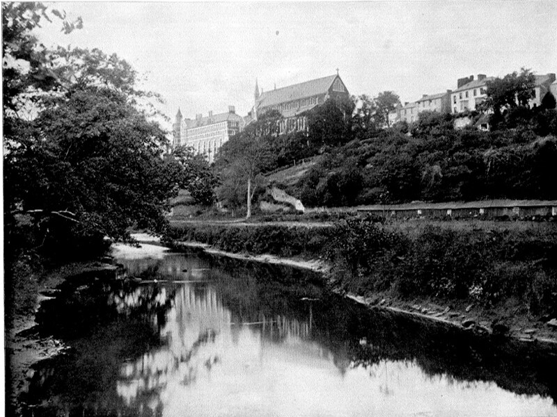
"ST. VINCENT'S CHURCH, SUNDAY'S WELL, CORK. -The sketch shows, seated picturesquely on an eminence above the river Lee, the Catholic Church of St. Vincent, which is the principal ecclesiastical edifice in the suburb of the city of Cork, known as Sunday's Well. It is so called from an ancient spring, said to have been made sacred to Druid rites before the era of Christianity in Ireland, and afterward utilized by the Catholic Fathers for baptismal purposes. The spring contains water peculiarly clear and cold, absolutely devoid of mineral flavor, and is much prized by the inhabitants of the district.
Owing to its fine situation, Sunday's Well was formerly much visited by the citizens of Cork, and many handsome homes existed there. The changes wrought by time, however, have not been favorable to the district as a fashionable residence locality, and the well-to-do people now build their dwellings elsewhere. Yet Sunday's Well is by no means abandoned, and the view to be obtained from the hill above the Lee, is regarded as one of the finest in the beauteous South of Ireland. There is a tradition to the effect that the gallant and ill—fated Lord Edward Fitzgerald resided, "on his keeping" in the vicinity, during the month of April, 1798. On his return to Dublin, he was captured, severely wounded and died in prison."