grazing
29 photos and 1 illustration tagged grazing, from 12 members of Flickr Commons.
When were these photos & illustrations taken?
Where were these photos & illustrations tagged?
16% of these photos & illustrations are geotagged.
Related tags
Tags that often appear on the same photos & illustrations:
- xmlns:dc=httppurlorgdcelements11
- powerhousemuseum
- pasture
- sheep
- field
- farm
- landscape
- cattle
- horse
- trees
- cows
- horses
- herd
- river
- usnationalarchives
- grass
- libraryofcongress
- mountains
- fence
- caribou
- feeding
- environmentalprotectionagency
- documerica
- cow
Members using this tag
- Powerhouse Museum
- U.S. National Archives
- The Library of Congress
- SDASM Archives
- National Library of Ireland on The Commons
- National Library of Scotland
- State Library of Queensland
- Florida Memory
- North East Museums
- Museums of History NSW - State Archives Collection
- Smithsonian Institution
- British Library
Photos & Illustrations
Show photos & illustrations photos (29) illustrations (1)
Photos & Illustrations tagged grazing:
Loading photos & illustrations…
Recent uploads
The last upload was May 2019.

The goats own the world. from National Library of Ireland on The Commons uploaded May 2019

george dong collection image from SDASM Archives uploaded May 2018

AL231 Davis Album Photo_000265 from SDASM Archives uploaded October 2013

South Coast, Pasture Land from Powerhouse Museum uploaded June 2013

Hillside view from North East Museums uploaded June 2012

Grazing sheep, near Blue Mesa Reservoir, 05/1972. from U.S. National Archives uploaded April 2012

Goat from National Library of Ireland on The Commons uploaded February 2012

Cavalry grazing horses from National Library of Scotland uploaded June 2010

Grassy slopes and Bunya Pines at Moggill, Brisbane from State Library of Queensland uploaded March 2010

A view of bison grazing on the Flathead Reservation in Montana from U.S. National Archives uploaded December 2009
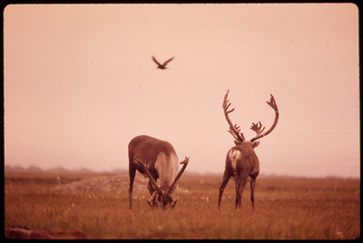
Caribou Feed on Lichens and Moss. The Bird Is an Alaskan Raven 08/1973 from U.S. National Archives uploaded October 2009


Conversations
Here’s a selection of the conversations happening on these photos & illustrations:
The goats own the world.
- 2 older comments, and then…
- Fred Dean Snr. said:
- Niall McAuley said:
- Fred Dean Snr. said:
- Billowy Room said:
- Ilia Alshanetsky said:
[Cynicht and Moelwyn (cattle study), Wales] (LOC)

-
Kest Schwartzman said:
article on the process of photochrom: en.wikipedia.org/wiki/Photochrom "A litho stone is coated with a thin layer of purified bitumen dissolved in benzene. A reversed half-tone negative is then pressed against this light-sensitive coating and an exposure in daylight made (taking from 10–30 minutes in summer, to several hours in winter). The bitumen hardens and becomes resistant to normal solvents in proportion to the light. The coating is then washed in turpentine solutions, removing the unhardened bitumen. It is then retouched in the tonal scale of the chosen color to strengthen or soften the tones as required. Each tint needs a separate stone bearing the appropriate retouched image, and prints are usually produced by at least six, and more commonly from 10 to 15 tint stones.[4]"
-
Siaron James said:
now spelt Cnicht
Stud ewes

from Powerhouse Museum
-
BobMeade said:
This photograph appears on page 171 of the book Yesterday's Tomorrows - the Powerhouse Museum and Its Precursors 1880 - 2005. Captioned: The highly folded skn and dense fleece of American Vermont sheep promised to greatly increase the Australian wool yield. Although they certainlhy contricuted in sone part to the Australian merion genotype, Vermont genes reduced the fineness of many flocks and increased susceptibility to blowfly strike." There is more about Vermont sheep and their wool on pages 172 - 174 of that book. More than a century of breeding has led these sheep to no longer have such pronounced wrinkling it seems. So this photograph is quite the historic curiosity of sheep breeding. Read a bit about it here: www.sheepmagazine.com/issues/28/28-6/Alan_Harman.html
-
Vermont Ed 802 said:
Wonderful historic photos!