grand
60 photos and 2 illustrations tagged grand, from 15 members of Flickr Commons.
When were these photos & illustrations taken?
Where were these photos & illustrations tagged?
25% of these photos & illustrations are geotagged.
Related tags
Tags that often appear on the same photos & illustrations:
- aviation
- raid
- 19
- aeronautics
- sdasm
- bregut
- design
- blackandwhitephotograph
- unitedkingdom
- unusual
- industry
- digitalimage
- fashion
- hotell
- mote
- klær
- canyon
- construction
- newcastleupontyne
- wall
- fascinating
- collection
- door
- pattern
Members using this tag
- SDASM Archives
- North East Museums
- Nasjonalarkivet (The National Archives of Norway)
- The Library of Congress
- State Library of Queensland
- U.S. National Archives
- The Field Museum Library
- Powerhouse Museum
- British Library
- California Historical Society
- Museum of Photographic Arts
- Public Record Office of Northern Ireland
Photos & Illustrations
Show photos & illustrations photos (60) illustrations (2)
A selection of photos & illustrations tagged grand:
Loading photos & illustrations…
Recent uploads
The last upload was September 2022.

Queen Elizabeth II addressing the crowds in Mackay from State Library of Queensland uploaded September 2022

Parliament Bldg., Angora (LOC) from The Library of Congress uploaded June 2021

Grand Hotel, Goomeri, 1989 from State Library of Queensland uploaded July 2020

Drysllwyn homestead now known as Raymont Lodge, Auchenflower, 1944 from State Library of Queensland uploaded October 2018

The auditorium at the Paramount Theatre, Newcastle from North East Museums uploaded August 2017

Passage to the rear of the stalls at the Paramount Theatre, Newcastle from North East Museums uploaded August 2017

Dining saloon on the ocean liner 'Mauretania' from North East Museums uploaded November 2016

1st class smoking room on RMS Mauretania from North East Museums uploaded July 2016

The entrance hall of the Laing Art Gallery, about 1916 from North East Museums uploaded October 2014

Grey's Monument, 1955 from North East Museums uploaded October 2014

Winner of Grand Prix, Sebring Florida from Florida Memory uploaded March 2014

Grand admission celebration. Portsmouth Square, Octr. 29th 1850 from California Historical Society uploaded September 2013


Conversations
Here’s a selection of the conversations happening on these photos & illustrations:
Grand Duchess Mikalovitsch (Anastasie) (LOC)
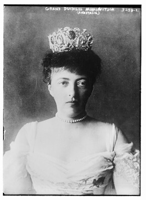
- aware health said:
- Art Siegel said:
[Grand Grocery Co.], Lincoln, Neb. (LOC)

- 105 older comments, and then…
-
Cory said:
What a deal!
-
discombobulated_dichotomy said:
Not sure about anyone else, but I am really thankful to see these kinds of photos online. I could browse them all day if I let myself.
-
partly cloudy said:
This, or a very very similar image appeared on Shorpy.com recently: www.shorpy.com/node/1810 Is LOC affiliated with Shorpy in any way?
-
JJ San said:
What a wonderful archive!
-
Kenichi Matsumoto said:
GREAT!!! I think this is worth joining. Thanks.
Cumberland Street looking south from Little Essex Street, The Rocks (NSW)
- 1 older comment, and then…
-
pellethepoet said:
beachcomber australia Re your note. 1900 resumption map confirms it is the Grand Hotel. View "Plan T" on Archives Investigator - gallery.records.nsw.gov.au/index.php/galleries/maps-and-p... Also, there is a photo on Photo Investigator (not yet on Flickr) taken from Essex Street and looking south-west that shows part of the Grand Hotel (note the name in the window) - investigator.records.nsw.gov.au/asp/photosearch/photo.asp... In the 1880s it was the site of the Coach & Horses Hotel - acms.sl.nsw.gov.au/_zoomify/2008/D00663/a1367458.html Regarding the intersection of this photo (Cumberland & Little Essex), going clockwise: The south-west corner -
 The (soon to be vacant) north-west corner -
 The north-east corner -
 I've never found a photo of the south-east corner, but the Old Erin-go-bragh Hotel once stood there. See 1890 map - acms.sl.nsw.gov.au/_zoomify/2008/D00663/a1367458.html
-
beachcomber australia said:
pellethepoet Thank you! I was thinking wrongly that the 'Frog Hollow' photo was taken from on top of the Grand Hotel, but that was Gloucester, not Cumberland St. All so very muddling ...
-
pellethepoet said:
beachcomber australia I'm just glad you didn't confuse 'Frog Hollow' with the one in Surry Hills. That would have been embarrassing :)
-
beachcomber australia said:
The 'North City Fire Brigade' seems to have been a volunteer organization from the 1880s, not part of the Metropolitan Fire Service. It suffered registration problems in 1896 (bureaucratic jealousies and bungling?) - trove.nla.gov.au/ndp/del/article/14059846 . Still going in 1903 - the fellow at the window could be one of these people - trove.nla.gov.au/ndp/del/article/14502563
-
noctorum said:
For those of us trying to navigate old sydney, I've put together a composite of the resumption map and something a little more recent. Enjoy!
