tropical
27 photos and 4 illustrations tagged tropical, from 12 members of Flickr Commons.
When were these photos & illustrations taken?
Where were these photos & illustrations tagged?
51% of these photos & illustrations are geotagged.
Related tags
Tags that often appear on the same photos & illustrations:
- queensland
- statelibraryofqueensland
- slq
- palmtrees
- islands
- publicdomain
- xmlns:dc=httppurlorgdcelements11
- beach
- vegetation
- bldigital
- pubplacelondon
- large
- mechanicalcurator
- bush
- palm
- tree
- hill
- smithsonianinstitution
- fish
- gardens
- fence
- plants
- state
- library
Members using this tag
- State Library of Queensland
- Smithsonian Institution
- British Library
- The Library of Congress
- Museum of Photographic Arts
- National Library of Medicine
- National Library of Ireland on The Commons
- New York Public Library
- Australian War Memorial collection
- State Library of New South Wales
- Library Company of Philadelphia
- Powerhouse Museum
Photos & Illustrations
Show photos & illustrations photos (27) illustrations (4)
Photos & Illustrations tagged tropical:
Loading photos & illustrations…
Recent uploads
The last upload was October 2025.

Cemetery at Yarrabah ca 1928 from State Library of Queensland uploaded October 2025

Cathedral Rock from State Library of Queensland uploaded January 2024

Ayer's Ague Cure: Is Warranted To Cure Fever & Ague and All Malarial Disorders from National Library of Medicine uploaded September 2023

Bush House at the Townsville Botanical Gardens, ca.1900 from State Library of Queensland uploaded February 2023

Tropical Fish, aquarium series, 1 April 1940, PIX magazine from State Library of New South Wales uploaded May 2021

View of Anzac Park in Cairns ca 1930 from State Library of Queensland uploaded January 2021

Queensland display at the British Empire Exhibition in London 1924 from State Library of Queensland uploaded July 2020

On the beach at Palm Island in North Queensland, ca. 1938 from State Library of Queensland uploaded May 2020
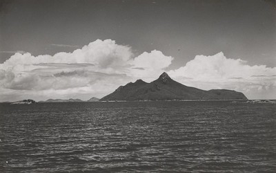
Pentecost Island in the Whitsunday Islands off the Queensland coast from State Library of Queensland uploaded July 2018

On the beach at Hayman Island off the coast of Queensland, ca. 1940 from State Library of Queensland uploaded July 2018

Newry Island near Mackay, Queensland, 1939 from State Library of Queensland uploaded July 2018

Soldiers on the beach on Green Island, Cairns, 1943 from State Library of Queensland uploaded July 2018


Conversations
Here’s a selection of the conversations happening on these photos & illustrations:
Studying the Cabbage Tree palms in Carnarvon Gorge August 1938

- John Nielsen said:
- Vesna Verencevic said:
Cathedral Rock
-
Vesna Verencevic said:
The Tablelands plateau offers a diverse landscape of lush mountains, green valleys, sparkling lakes and streams, tumbling waterfalls, grassy savannah, endless plains and pockets of ancient rainforest. The Atherton Tablelands encompasses an area of around 64,000km² (25,000mi²) and forms part of Queensland's Great Dividing Range. Source: www.honeymoonguide.com.au/australia/atherton-tablelands.html
-
Vesna Verencevic said:
Geological history About 100 million years ago, the eastern edge of the Australian continent extended much further to the east, before tectonic forces fractured the eastern margin, pulling it apart. At the same time, slowly rising mantle material caused a doming up of the continental crust. As the eastern part of the continent broke away, it gradually sank below sea level.[1] Since that time, the uplifted western portion has been slowly eroding westwards, creating the abrupt Great Escarpment, which separates the coastal plain to the east from the uplifted tablelands to the west. From over 4 million to less than 10,000 years ago,[2][3] a series of volcanic eruptions occurred over the Atherton Tablelands. The oldest eruptions created large, gently sloping “shield volcanoes” that produced extensive basalt flows. These flows filled the pre-existing valleys, producing a relatively flat tableland surface, instead of the more dissected landscape that would have existed previously. About one million years ago, the style of eruption changed. The lavas became more gas-charged, throwing fragmented lava into the air which built the numerous, small scoria cones, such as the Seven Sisters, near Yungaburra. Some of the rising magma interacted with groundwater, producing violent eruptions that led to the formation of maar volcanoes, such as Lake Eacham and Lake Barrine. Although all the volcanoes in the Atherton Basalt Province are regarded as being extinct and volcanism has been waning over time, given the relatively recent activity, it is possible that further eruptions could occur in the future.[4] Source; en.wikipedia.org/wiki/Atherton_Tableland
Soldiers on the beach on Green Island, Cairns, 1943
-
Vesna Verencevic said:
Green Island is a coral cay northeast of Cairns in Tropical North Queensland. The island boasts an unspoiled rainforest, stunning beaches, and a surrounding reef ... so close that you can snorkel directly off the beach. Source: www.queensland.com/us/en/places-to-see/destination-inform...